Environmental Department
Table of Contents
The Big Pine Paiute Tribe's Environmental Department works to protect the health, land, air, and water resources of the Big Pine Reservation for present and future generations.
Overall Objectives
- Maintain an environmental planning program.
- Protect the health and safety of Reservation residents and visitors.
- Ensure compliance with all environmental laws and regulations.
- Participate in local, state, and national environmental decision-making.
U.S. EPA grants empower the Tribe to protect its resources today so that future generations may enjoy clean water, air, and land.
Environmental Advisory Board
Created under the 2012 Tribal Environmental Policy Ordinance, the Environmental Advisory Board (EAB) comprises Tribal members serving 2-year terms. Meeting bi-monthly, the EAB advises Tribal Council on environmental issues. Members can attend trainings and represent the Tribe at key events.
Solid Waste and Recycling
Residents are responsible for properly disposing of household waste by contracting with a regional provider or hauling to a local landfill or transfer station. For general waste information, visit Inyo County Solid Waste .
The Tribe's waste efforts are supported by U.S. EPA GAP grants. Key goals include reducing landfill volume and reservation blight.
Clean Up Your Space
Download our helpful guide: Getting Clean
Curbside Recycling
Recyclables are collected every Tuesday . If you need a bin or guidance, contact the Environmental Department at (760) 938-2003.
View our recycling quick list: BPPT RECYCLE list 2025
Accepted Items
- All CRV-marked cans and bottles
- Glass containers (no windows/mirrors)
- #1 and #2 plastics
- Cardboard and chipboard
- Newspapers and office paper
- Clean metal cans
Items must be clean and empty .
Special Item Collection (Call Ahead)
- Mattresses
- E-Waste (computers, monitors, etc.)
- Large appliances and scrap metal
- Household hazardous waste
- Fluorescent bulbs
A fee may apply (see: County Fee Schedule )
What Not to Recycle
- Soiled food containers, greasy boxes
- Styrofoam, bubble wrap
- Shiny or glued paper
- Cloth, rubber bands, old photos
- Broken or specialty glass (e.g. mirrors)
Junk Vehicles
Abandoned vehicles cause health and safety issues. The Tribe may order removal at the landholder's expense.
View: Junk Vehicle Ordinance
Yard Waste
Recycle yard waste into mulch or compost. Mulch is available free at the Bishop Sunland Landfill.
More info: In the Garden – Mulch
Tips:
- Remove weeds when small.
- Alter watering habits to reduce overgrowth.
- Tackle tumbleweeds early. Read More
Compost at Home
Turn yard and food waste into rich soil. Learn How
Household Hazardous Waste
Dispose of:
- Paints, cleaners, solvents
- Motor oil, antifreeze
- Pesticides, fuels
Free disposal events happen quarterly at Inyo County collection sites. Learn more at Inyo County HHW
Oversized Items and Trailers
Large junk (like furniture or trailers) often incurs disposal costs. Avoid placing dilapidated trailers—removal is expensive.
Litter
Please pick up litter as it appears. A clean community is a healthy one.
Additional Resources
Air
The Big Pine Tribal Air Program recognizes that breathing clean air is important to human health. Observations in recent years suggested a general deterioration in visibility and overall air quality, possibly due to factors such as dust blowing off the land surface, smoke from wildfires, and polluted air moving into the Big Pine area from afar.
To begin to better understand the air around us, the Tribal Air Program seeks to characterize ambient (outdoor) air pollutants. The Tribe gathers data on PM10 and PM2.5 (which is particulate matter 10 microns or 2.5 microns in diameter and smaller, respectively), analyzes patterns and trends, and attempts to identify the sources of the pollution. We use an Environmental Beta Attenuation Monitor (E-BAM) to measure particulates, and we compare these data with known standards as well as with data available from other instruments in the region.
We monitor visibility on the Reservation using a webcam. Below is a live image showing visibility south of the Reservation.
The Tribe continues to grow its air program by:
- Gauging the Tribal community's interest with regard to indoor air quality;
- Educating youth and adults about air pollution concerns and what may be done to improve air quality and reduce health risks;
- Developing information for the Tribe on the nexus between climate change and air quality; and
- Engaging in regional and national efforts to improve air quality.
Tribal Weather Info
http://trexwww55.ucc.nau.edu/cgi-bin/daily_summary.pl?cams=1033
What Exactly is a High Desert Climate?
By Cindy Duriscoe
We experience quite the extremes living in the Owens Valley. Think about the variety residents experience during one year of weather. We live in a temperate desert with hot, dry summers and snowy winters. The basin and range topography characterizes this desert: wide valleys bordered by parallel mountain ranges generally oriented north-south. We experience more sunny days than not and little precipitation (snow and rain) on the valley floor. Summers are clear and dry, often extending into autumn even as temperatures cool. In the high-country winters are noteworthy for long periods of mild temperatures and sunny days, under the atmospheric influence of warmer Pacific air masses. The Great Basin region is extremely mountainous, and the temperatures vary depending on the elevation. In general, temperature decreases 3.6 degrees F for every 1000 feet gained in elevation. This translates to as much as a 30 °F (17 °C) difference between mountain tops and valley floors on the same day at the same time. In the heat of summer, this difference can be even more pronounced. An example of the temperature extremes we experience occurred in February 2016, where the monthly temperature ranged from 16 to 72 degrees Fahrenheit. Our part of the Great Basin area does at times experience wild swings in temperature, gusty winds especially during the fall and spring. This is an expression of "weather". Weather refers to short-term changes in the atmosphere, climate describes what the weather is like over a long period of time in a specific area. Different regions can have different climates. To describe the climate of a place, we might say what the temperatures are like during different seasons, how windy it usually is, or how much rain or snow typically falls. When scientists talk about climate, they're often looking at averages of precipitation, temperature, humidity, sunshine, wind, and other measures of weather that occur over a long period in a particular place. In some instances, they might look at these averages over 30 years.
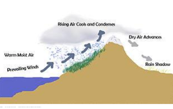
Another sometimes extreme annual weather factor is precipitation (the rainfall we receive that lands on the ground) or lack of. Weather coming in from the Pacific Ocean quickly loses its moisture as rain and snow once it is forced up and over the steep mountains. By the time it reaches the east side of the mountains, little moisture is left to bring to the desert. The rain shadow effect is more pronounced closer to the Sierra Nevada, with yearly precipitation in the Great Basin desert averaging 9 inches in the west and 12 inches in the east. Moisture that manages to reach the ecoregion tends to precipitate as rain and snow in higher elevations, primarily over the region's long, parallel mountains. The Big Pine area of the Great Basin receives annual averages for precipitation of around 5-7 inches. The average water content of snow in January was 0.3 in. February and Nov. Dec. was 0.1 in. (Average-Weather-in-Big-Pine-California-United-States-Year-Round).
Another noteworthy weather factor is wind. With some exceptions, wind generally increases with elevation or altitude, and thus strong winds are often encountered on mountain tops and ridges. The dominant source of airflow throughout the year is the Pacific Ocean. In summertime, we experience a clockwise whirl of air that is several hundred miles across. This accounts for the high-pressure systems that keep our air clear and dry. During this time of year, an afternoon breeze arrives at the Sierra crest about noon and Owens Valley about two hours later. We also experience a similar diurnal effect in canyons when on warm, sunny mornings heated air rises along the ground creating a valley breeze. During the wintertime when cold fronts are approaching the Owens Valley
What is a Health Advisory?
When local air pollution levels exceed certain thresholds that impact human health, an air quality advisory is put into effect. When this happens, all individuals living in or traveling within the affected area are advised to be aware of potential health concerns associated with poor air quality conditions. Most individuals with respiratory conditions (such as COPD and asthma) and individuals with existing cardiovascular conditions (such as angina, previous heart attack, and congestive heart failure) may notice a worsening of symptoms due to the poor air quality conditions. These individuals should monitor for worsening of symptoms and take the precautions routinely recommended by their physicians if a worsening of symptoms occurs.
The Great Basin Unified Air Pollution Control District will issue air pollution health advisories when air pollution exceeds selected trigger levels. District staff will take hourly readings of wind speed, wind direction, and particulate pollution levels in Mammoth, Bishop, Lone Pine, Olancha, and Keeler during normal business hours. Once we are reporting regular particulate matter data, Big Pine will be included in this advisory system.
Health advisory notices will be faxed and emailed to schools and interested citizens in the affected communities and to local media outlets. Health advisories will remain in effect for the remainder of the day and, if appropriate, will be reissued as conditions change.
A Stage 1 air pollution health advisory will be issued when hourly particulate pollution (PM10) levels exceed 400 micrograms per cubic meter (µg/m³) for dust and 100 µg/m³ for wildfire smoke. A Stage 1 health advisory will recommend that children, the elderly, and people with heart or lung problems refrain from strenuous outdoor activities in the impacted area.
A Stage 2 air pollution health advisory will be issued when hourly particulate pollution levels exceed 800 µg/m³ for dust and 200 µg/m³ for wildfire smoke. A Stage 2 health advisory will recommend that everyone refrain from strenuous outdoor activities in the impacted area.
For More Information...
For other Owens Valley air information, visit: Great Basin Unified Air Pollution Control District: https://www.gbuapcd.org/
For your area Air Quality Index (AQI) visit: https://www.airnow.gov/?reportingArea=Bishop&stateCode=CA
The Environmental Protection Agency Data website: https://www.epa.gov/outdoor-air-quality-data
California Air Resources Board: https://ww2.arb.ca.gov/homepage
For the latest fire information visit: https://www.nifc.gov/fire-information
Water
The Tribal Water Program
Control of water resources and water availability have been dominant themes in Owens Valley, especially during the last century. Water available to the Big Pine Paiute Reservation consists of a short reach of Big Pine Creek, which runs through a part of the Reservation, groundwater that the Tribe pumps to supply domestic uses, and water diverted from Big Pine Creek by the Los Angeles Department of Water and Power and delivered to the Tribal community primarily for outdoor irrigation.
Water quality on and near the Reservation is generally known to be very good. The Tribe's current Water Program focuses on surface and groundwater and addresses non-point source pollutants as well. The program is described below:
Surface Water Quality Monitoring Program
The Reservation received authorization from the EPA to implement Tribal Water Quality Standards in 2006 under Section 518(e) of the Clean Water Act to be treated in a manner similar to a state ("TAS"). The Tribal Water Quality Standards are intended to protect public health and aquatic life and to maintain or enhance water quality in relation to the beneficial uses of the water. The beneficial uses designated for Big Pine Creek by the Big Pine Paiute Tribe of the Owens Valley (Tribe) are listed below:
- Agricultural Supply
- Cold Freshwater Habitat
- Commercial and Sport Fishing
- Freshwater Replenishment
- Ground Water Recharge
- Municipal and Domestic Supply
- Water Contact Recreation
- Non-contact Water Recreation
- Spawning, Reproduction, and Development
- Wildlife Habitat
- Cultural
These beneficial uses have been designated by the Tribe to ensure that the waters of Big Pine Creek continue to show excellent water quality. In order to protect the beneficial uses from degradation, the Tribe established Water Quality Objectives in both numerical and narrative forms.
Water monitoring has been conducted on Big Pine Creek since June 2001. For the first three years, monitoring occurred at two sampling points, upstream and downstream of the Reservation. The two sets of data proved very similar and fell within an acceptable range of variation. In 2005, sampling was consolidated at one location on the Reservation. The initial water samples from Big Pine Creek were used to provide baseline data on the quality of water flowing through the Reservation. Subsequent monitoring of Big Pine Creek has been performed to verify earlier results and to monitor changes in water quality. The Tribe has also sampled Big Pine Creek for benthic macroinvertebrates on an annual basis since 2006.
Ground Water Quality Monitoring Program
A monitoring program was initiated to assess the quality of groundwater in the aquifer located beneath the Reservation. The Tribe implemented a monitoring plan to 1) establish baseline information regarding the current quality of water in the shallow aquifer, 2) assess the impacts of long-term pumping, seasonal recharge/discharge cycles, and existing land uses, and 3) track changes in contaminants.
Monitoring well BP Res 5 was installed near the southwestern edge of the Reservation in 2002, and water quality monitoring has been conducted at BP Res 5 since August 2002. Analysis of the groundwater from BP Res 5 has assisted in determining the water quality of the aquifer and has provided background data for continual monitoring of water quality changes.
Ground Water Level Monitoring Program
Water levels have been measured at monitoring wells, drinking water wells, and piezometers throughout the Reservation since November 2004. Three monitoring wells are equipped with dedicated data loggers for continuous monitoring, and seven additional sites are measured monthly using a Solinst Water Level Meter, Model 101, with a P4 Environmental Probe. The water level measurements provide key hydrologic data needed to assess aquifer recharge and contaminant transport pathways. Water level data also provide records of the temporal response of the shallow and deep aquifers to natural recharge cycles and local pumping.
Non-Point Source Management Program
The overall purpose of the Non-point Source (NPS) Management Program is to support all beneficial uses described in the Tribal Water Quality Standards and protect or restore watershed conditions on the Reservation. This purpose shall be realized through the integration of NPS prevention activities with water quality monitoring, other tribal environmental programs, and public outreach to ensure the protection of Tribal water resources. Tribal NPS activities being implemented, which assist in protecting the Tribe's water resources, include enforcement of Tribal Water Quality Standards, monitoring of surface water and groundwater quality, collecting streamflow measurements, improving the Tribe's irrigation water delivery system, executing a solid waste management program, enforcing a hazardous waste policy, and continuing public education. Specific activities to assist in managing nonpoint sources include: management of invasive non-native plant species, prevention or reduction in the frequency of wildfire, further development of sustainable agricultural and residential practices, anticipation of climate change impacts, and collaboration with others.
Staff
-
Sally ManningEnvironmental Director
-
Elaine ChowWater Program Coordinator
-
Cynthia DuriscoeAir Program Coordinator
-
Gregory S. SprattSolid Waste Technician
-
TBDEnvironmental Technician